THE GEOGRAPHICAL ATLAS · CRETE CHRONICLE
How Crete was created
Γεωλογία
Sea deposits became mountains. A reading guide to rocks, fractures, karst and changing coastlines, with a timeline and explanatory schematics.
From seabed to island
The history of Crete does not begin with the Minors or even with the present island. Many rocks were formed in older seas, long before the present mountains and coasts existed. So the age of the material and the age of a mountain form are different things.
Deposition, burial, deformation, lifting and erosion work on different time scales. It is misleading to see one layer of stone as one moment when the whole of Crete was absent. The landscape is the result of successive processes that, moreover, did not go the same everywhere.
The timeline below uses wide periods and processes. It is not an exact dating of each place. Geologic locations of the geoparks give much more precise explanation for individual layers and areas.
- Older seasDeposition of calcium and other sediments.
- Distortion and burialStones change and packages shift relative to each other.
- Removal and cuttingMountain relief, basins and drainage networks are developing.
- Changing coastsLand movement, sea level and sediment change the coastline.
- The current landscapeWater, weathering and human use continue to form the island.
Plate movement is not a simple collision
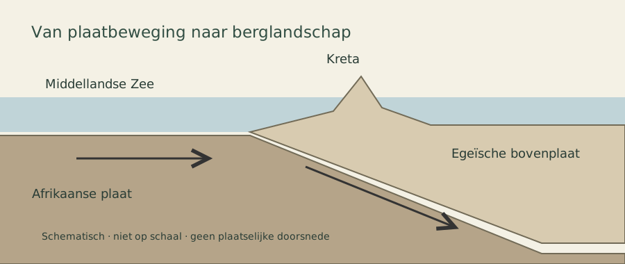
Crete lies in the wider geodynamic world of the Hellenic arch. The movement of tectonic plates, the diving of lithosphere and distortion in the upper region are part of that cohesion. Therefore, the island cannot be understood as a loose rock that only slowly rises.
Within this large context, fractures, lifting and extension can differ regionally. An elevated coast on one side of the island does not prove an identical movement on the other side. Also, slow distortion can exist alongside sudden displacement during earthquakes.
The diagram shows concepts, no cross-section at a particular Cretan location. The arrows describe a general process; they predict no earthquake, direction of a future fracture or local speed.
What you can see from rocks
A light rock is not automatically the same rock as the light rock a kilometer away. Limestone, pebbles, scalary layers and other rocks can occur in the same mountain next to or above each other. Look at structure: are there layers, fractures, folds, caves or a clear transition to other material?
A stone on a beach can have been moved by water and a building block can have been delivered from somewhere else. The place where you find it is not automatically the place where it was formed.
Geopark locations are suitable to connect that learning to named rock packages. Use a plate or source to test your first impression. For special geological traces, looking is more valuable than taking a piece; the connection to the environment is part of the information.
The white layers along the road · marl, limestone & plaster
A road cuts through a hill and suddenly exposes an almost white wall. The layers seem to consist of chalk: pale, dry and sometimes so soft that material is loosened under a fingernail. Such spots are visible during a ride through East Crete, even when you travel from Agios Nikolaos towards Sitia. They make something visible that is usually hidden under olive trees, soil and shrubs: the construction of the landscape itself.
Yet not every white layer has the same name. Mirror, limestone and plaster can all be light to muscle white, but differences in composition and origin history. The colour is a beginning of perception. For a certain recognition also the structure, the coherence of the material and the precise location are necessary.
Sitia Geopark describes in East Crete both lightly coloured limestones and marls from the Miocene as young, white to greenish marls from the Pliocene. A white wall is therefore not automatically a deposit from the Messinian salt crisis. Similar colours can be associated with different ages and environments.
Sitia Geopark · geology of East Crete .
Mergel · a mixture of lime and clay
Μάργα · transliteration: margaMergel is sediment or sediment rock in which clay and lime material are mixed. So it is not a single mineral. The ratio between the constituents and the degree of hardening differ; a marl can be soft and earthly eyes, but also firmer.
A simple starting image is a water bottom with very fine material. Lime-bearing material and clay are mixed together. If the supply or environment changes, the composition of the next layer can also change. Burial and compaction are then part of a much longer history. The fine lines you see today are not a calendar of which each stripe automatically represents one year.
Merge walls often look matt and fine grain. Engagement can make flakes, crumb zones and small ledges. Softer parts can turn back while a firmer layer sticks out. The result sometimes resembles a pile of thin pages. That's a useful description of the appearance, but not yet a complete rock determination.
Arkansas Geological Survey · marl . · British Geological Survey · Rock Formation
Limestone · not always a hard solid rock
Ασβεστόλιθος · transliteration: AsvestólithosLimestone consists predominantly of calcium carbonate, for example, it may contain material that once belonged to shells and other organisms, some limestones clearly show such remains; others are much finer in structure.
In a wall, limestone banks can be identified as thicker, sturdier steps. Look at the continuous layer, the fracturing surfaces and the connection to softer interlayers. However, the name limestone includes a variety of rocks. Also chalk is a fine grain limestone. Oh, it's soft, so it can't be limestone.
Moreover, the light sediments in a low hill do not need to have the same history as the large mountain massifs up ahead. Crete has ancient rock units and much younger deposits. Their colour may resemble one another while their geological story differs greatly.
British Geological Survey · limestone decanoate · British Geological Survey · Rock Formation
Gypsy · a white mineral with crystal water
Γύψος · transliteration: gýpsos. Gyps is calcium sulphate with crystal water: CaSO4·2H2O. So it has a different composition than the calcium carbonate of limestone. Of course, plaster can be fine and white, but also have translucent crystals or a fibrous structure.
Gypsy can strike when water with dissolved substances becomes sufficiently concentrated. Such a evaporation deposit is called a evaporite. Also anhydrite conversion can produce plaster. Therefore, a white plaster layer is not simply a lot of kitchen salt. Stone salt consists of Halite, with the composition NaCl; plaster and stone salt are different materials, even if they belong to a related evaporation history.
National Park Service · plaster enoate
Rough and scratchable with a nail: what does that tell you?
This extra clue makes plaster a serious possibility. 2 on the Mohs scale; a fingernail is round in the usual comparison 2,5 A nail can therefore make a real groove in plaster. Calcite, an important mineral in limestone, stands at 3 and is not normally scratched by such a nail.
But a rock is more than a loose mineral crystal. When a soft marl or weathered limestone crumbs under your nail, sometimes mainly grains or flakes are pushed loose. Then you measure the small cohesion of the surface, not necessarily the hardness of the individual minerals. A rough appearance is not unique for plaster either.
White, rough and nail scratchable is therefore a clue, not a definitive determination. The difference between a permanent scratch in coherent material and the crumbling of an outer layer is essential. Together with an overview photo, a detail and a location, this observation can be very useful.
National Park Service · minerals and fingernail on the hardness scale .
| Material | Composition | Possible view | Important distinction |
|---|---|---|---|
| Mergel · Μάργα | Lime with clay | Matt, fine-grained, sometimes crumbly or finely layered | A loose surface can crumble under a nail. |
| Limestone · Ασβεστόλιθος | Mainly calcium carbonate | Banks, fracturing surfaces, sometimes fossils; rock hardness varies | Soft limestone also exists; chalk is an example. |
| Gypsy Γύψος | Calcium sulphate with crystal water | Fine white material, crystals or fibres | The mineral can be scratched with a nail; it is not a kitchen salt. |
The Messinian salt crisis · when the sea changed
Some of the evaporites in Crete are part of the Messinic salt crisis, about 5.97 to 5.33 million years ago. This episode took place at the end of the Miocene. The crisis concerned the marine system: exchange with the ocean, evaporation, freshwater supply and salt content were in an exceptional relationship.
How evaporation can make a rock layer
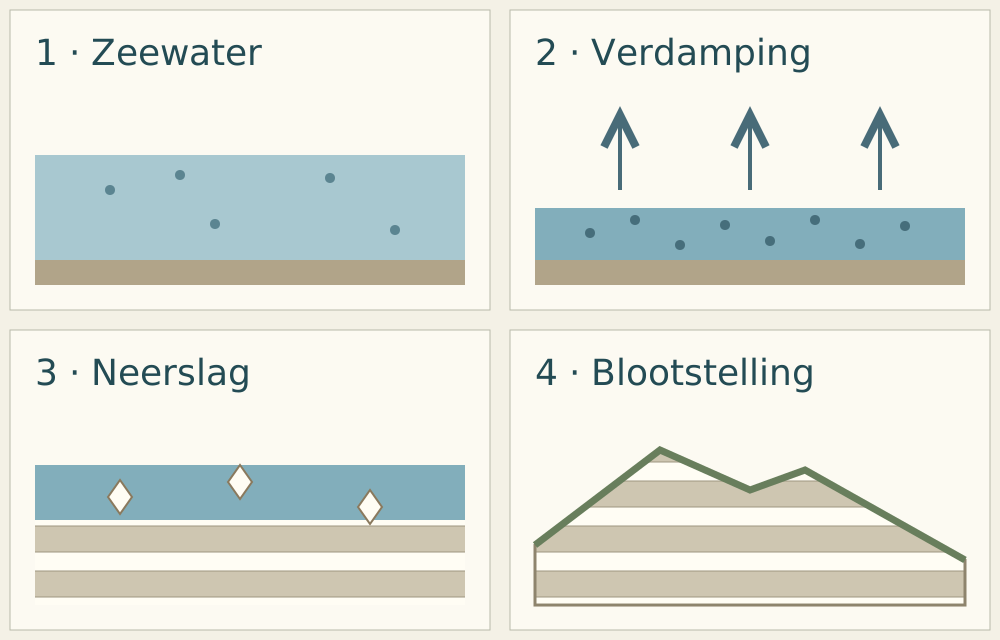
When water evaporates while the dissolved substances remain, their concentration increases. The supply of new water and the drainage to other water bodies determine how far that process goes. In suitable conditions minerals can fall and accumulate as sediment. A change in the water balance can thus leave a visible layer.
Research into the final phase of the salt crisis describes variations of plaster and marl and connects it with a changing water balance. Such sequences do not reflect a state that remained the same everywhere. Utrecht's research at the source below deals with a Sicilian series: it helps understand the processes, but does not date any Cretan road wall.
Utrecht University · water levels and the Messinian salt crisis .
Was the Mediterranean all dry?
The large evaporite packages provide tangible evidence of exceptional circumstances. How deep the water stood, which parts fell dry and how the connection with the Atlantic was exactly going, continue to be subject to research.The popular image of one completely empty sea, followed by one huge waterfall, is often told more firmly than the discussion justifies.
An overview study by Roveri, Lugli and Manzi from 2025 also discusses indications for a longer-standing ocean connection and more gradual processes. Therefore, this guide does not present complete dry-fall and catastrophic refill as undisputed facts.
Roveri, Lugli & Manzi (2025) · facts and assumptions about the salt crisis .
Why old sea layers are now sitting in a hill
Deposition is the beginning, not the end. A package can later be buried, distorted and become visible again by lifting and erosion. Then a road cuts a new plane through the terrain. The wall next to the asphalt brings together very different time scales: the origin of the material, the development of the island and the recent construction of the road.
Psiloritis Geopark describes Messinian evaporites around Agia Varvara, now high above the current sea. This is a concrete example from central Crete. It shows the connection with the later development of the island, without putting a name or age on every white layer in Lasithi.
From Agios Nikolaos to Sitia · reading the landscape
The white walls that you notice on a drive through East Kreta are a good reason to look more closely. . .A light, rough wall with thin bands . . . A Messinic plaster . is already an interpretation of the composition and old age. For that second step more information is needed.
What a location on a map tells and does not
The white layer is marked on a map along the road with the label Epar. Od. Kato Choriou.. The marking indicates the location of the sighting. For a geological explanation, you then link that position to a geological map and to the structure of the material. The combination white, rough and nail scratchable is important field information; small photo miniatures still show insufficient detail to determine one rock name.
Altsi · a real cast in the region
The producer Heracles describes materials containing plaster and anhydrite in Altsi, in the region of Sitia. Sulphate rocks are actually found in East Crete. This makes plaster a relevant possibility, but does not prove that another white wall along a road consists of the same package. The quarry is a geological regional example here, not a proposed visit point.
HERACLAES Group · plaster and anhydrite at Altsi .
Xerokambos and Komolithi as comparison spots
Sitia Geopark mentions clay marshes at Argilos in Xerokambos. This spot is located outside the Agios Nikolaos.Sitia, but shows that light, soft materials in the region can also have a different composition than plaster. The geological overview of the geopark helps place such differences.
Sitia Geopark · geology of East Crete .
Much further west are the cone-shaped hills of Komolithi near Potamida, in the region of Kissamos. The Crete region describes them as soft clay hills formed by erosion. They are a comparison, not an identification of an eastern road wall. A striking white landscape is not by itself a plaster landscape.
Region of Crete · the clay hills of Komolithi
A small reading pointer for the road
- Laagverband: Do the tires run through, do they hell or are they interrupted?
- Reliëf: stick out more solid parts while others turn back?
- Structuur: Does the surface look matt, grainy, fibrous or crystalline?
- Samenhang: Is it a real scratch or a loose weather?
- Ligging: Keep an overview, a detail and the exact position.
An observation does not need to damage any material. Look at a wall from an accessible place outside of traffic and leave the layer bandage intact. A photo with context is often more useful for later research than a loose white stone without origin.
The next step in the story is solution and karstLimestone and plaster can both dissolve, but in different ways and at different tempo. That connects the white layers to the water landscapeGeology also determines how water moves through the subsurface and how the terrain changes.
Karst · a landscape with a background
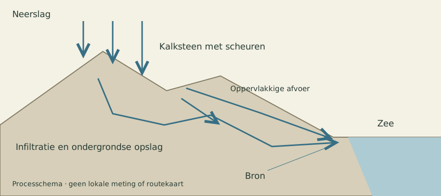
In soluble rocks, water can travel a large part of its way underground, crevices become larger, spaces become connected and the surface can form bowls, sinkholes and dry valleys, which we call karst.
A high plain without visible drainage is therefore not necessarily a closed container. Water can disappear through openings in the soil. In the opposite way, a source lower in the landscape can supply water from a larger, invisible area.
Caves are one expression of that system. Their dripstone tells about deposition from water; their larger form may be associated with other periods of solution and flow. grottenatlas shows how geological spaces became a sanctuary, shelter or research area.
Falassarna · port landscape and changed coast
The ancient Falassarna reveals the relationship between archaeology and coastal change. An old port is not only read with the current waterline as its starting point.
A port contains clues as to where people built and how the coast was used. To understand why remains are different from the sea, archaeological observations must be combined with geological research. Not every change is the result of a change in sea level.
Look at height, distance to the sea and the form of old entrances. Then compare the harbour remains with the current beach landscape. The same place can be a chapter from trade history and an archive of coastal development.
Zakros · old sea heights in the landscape
Around Zakros the geopark describes geological locations along the coast, including the landscape of marine terraces. Such forms help to investigate older coastal situations.
A terrace may seem like a flat strip above the sea for a hiker. For a geologist his shape, deposition and coherence clues. They need to be looked at together before an age or old water level can be attached to it.
The link with Pelekita and the old quarry shows that natural history and material use converge on the same coast. Use the georoute as a source for understanding; the original route description is not an actual confirmation of each passage.
Understanding earthquakes without predictions
An active geological region requires care in language. A visible break is not a clock and a long period without a felt quake is not proof that an area is safe or short-term. Geologists investigate repetition, displacement and uncertainty; this does not provide a reliable day forecast.
Historic damage must also be investigated by place and period. A collapsed wall can have more than one cause. A guide who links each ruin to one famous earthquake makes the story easier than the data allow.
For current events and instructions for action, you use the competent scientific and public authorities. This chapter explains the landscape; it is not a warning system. If you visit Crete, you can look at historical monuments and geological traces with more attention when these different types of knowledge remain apart.
Spili · landscape and fracture research
Around Spili, geological research has been carried out on fractures and older earthquakes, and the place name helps to connect a research context with the broader question of how distortion is recognised in a landscape.
The atlas point is located at the site and does not sign a fault line. A geological fracture accurately locates and dates requires research; a steep wall or straight line in a valley is not in itself evidence.
Read the sources as a way to test observations. The goal is not to predict an earthquake during a visit, but to better understand how Earth scientists deal with traces, measurements and uncertainty.
Natural History Museum of Crete · Geologic Research Bibliography
Rouvas · rocks, embossing and water
The Rouvas environment is located in the southern Psiloritis world. It is an appropriate geographical context to read forest, relief and water management of a limestone mountain.
A green landscape and underground drainage do not exclude one another. The properties of rocks and the location of springs work together with height, shelter and soil.
This passage is a landscaped entrance; an independent extensive forest reportage remains recognizable as an extension wish in the admin. For example, a short description is not wrongly counted as a complete forest guide.
Psiloritis Geopark · geologic locations · Psiloritis Geopark · karst landscapes .
& Continue reading resources
Sources and content checked on October 22, 2026. The viewing questions and proposed combinations are editorial. Locations are area points, no access ticket or extended route. For opening hours and current restrictions, you use the listed administrators. The schematics are explanatory illustrations, no navigation chart or measurement.