ISLAND FILE · CYCLONES
Santorini
Σαντορίνη · Θήρα
An island of fire, sea and human ingenuity. From the city under the ashes to the villages above the caldera, discover Santorini with the same attention as Crete.
19 chapters · 25 card points · content checked on 22 October 2026
To the island map ↓Santorini · an island to read low by low
From the sea Santorini first seems to be a dark wall with a white edge. Only closer are the white spots houses, the stripes stairs and the shadows courtyards. The villages do not just hang over a beautiful bay: they are on the edge of a volcanic landscape. The water between the islands fills a caldera, a large collapse structure that is part of a much longer eruption history. If you only look at the sunset, you will see an impressive setting. If you stay longer, you will discover a connection between rock, house, field, harbour and archaeological city.
Santorini is also called Thera of Thira · Θήρα. It is located in the southern Cyclades, north of Crete, and belongs to the region of South Aegean Islands. Santorini sometimes means the main island and sometimes the whole island complex. This distinction helps to read maps, excursions and historical stories. Thirasia, Aspronisi and the two Kameni islands are part of the landscape of the same caldera, but are not neighborhoods you drive to.
The same look as on Crete, another scale
In Crete long mountain ranges, four large regions and extensive agricultural areas determine the journey. On Santorini, the contrasts are closer together. A museum morning, a walk in the village and a beach afternoon can be very well matched geographically. However, a short distance does not automatically make a day easy: the caldera wall, the road pattern, altitude differences and crowds determine how much you really see. Therefore, plan to tick off each landscape area instead of every famous image.
| Subject matter | Crete | Santorini |
|---|---|---|
| Landscape | Mountain massifs, plateaus, gorges and large coastal differences | Calderarand, volcanic slopes and an older mountain massif in the southeast |
| Travel layout | Chania, Rethymno, Heraklion and Lasithi | Caldera villages, inland, east and south coast, and the islands in the caldera |
| Antiquity | Among other things, the Minoan Palace World | The prehistoric Akrotiri and the much later city of Thera |
| Agriculture | Olives, wine, horticulture and mountain farming | Lowly kept vines and local crops in a dry landscape |
Geography · four landscape worlds
The west side · living on the caldera
Fira, Firostefani, Imerovigli and Oia form the most famous line of vision in Santorini. The building follows the edge and the slope, with a different relationship between street, terrace and abyss. Look not only over the edge, but also back: where does the access road start, where does the pedestrian zone begin and how much altitude span a staircase? This makes the shape of a village more understandable than with just a panorama.
Inland · an island of work
Around Pyrgos, Megalochori and Emporio, the attention shifts from the horizon to the ground level. Here are land borders, low vines, heirloom walls, vaults and village squares. The landscape is not an empty space between the famous places. It is the environment in which people had to organize their food, building materials and income. Watch a field and then walk into a village street is a simple way to see that connection.
The outside coast · another sea contact
On the east and south side are the famous beach resorts. Kamari and Perissa are separated by Mesa Vouno; along Perivolos the coast opens. At Vlychada light, worn-out walls attract attention. So a caldera terrace and a beach accommodation offer different experiences. Choose your sleeping place on the daily desired use of the island, not only on the view of one photo.
The older rock · Mesa Vouno and Profitis Ilias
Not every height on Santorini is a volcano cone. In the southeast, a parent, pre-volcanic rock foundation comes to the surface. Mesa Vouno wears the ancient Thera; the massif of Profitis Ilias determines the higher interior. That makes Santorini geologically richer than the summary of a lava island. Dark lava, light pumice stone and older rock belong to different chapters of the same landscape biography.
Municipality of Thira · Climate and Land Forms · Hellenic Heritage · Mesa Vouno and Thera Ohio
Vulcanism · how the caldera was created
Santorini is located on the Hellenic volcanic arch. Under the southern Aegean region, lithosphere of the eastern Mediterranean dives away: subduction. That large tectonic system forms the background of volcanicism, while local fractures and magma movements help determine the behaviour within a separate volcanic area. Crete and Santorini are part of the same broad geodynamic world, but have different positions and landscape-forming processes. Therefore, it is wrong to simply imagine the Cretan mountain ranges as the continuation of a Santorini volcano.
Geophysical Research Letters · tectonic location and volcanic turmoil .
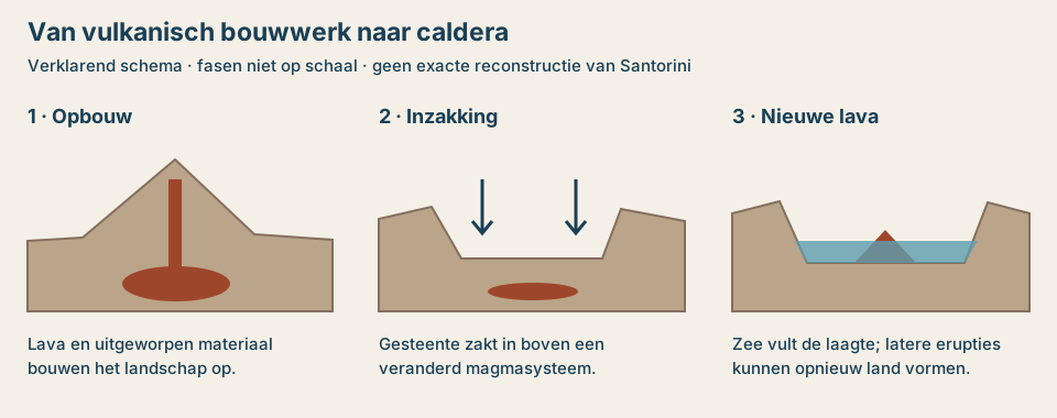
A caldera is something other than the small opening that you might imagine at the word crater. In the event of a large eruption, so much magma can disappear from an underground system that the rocks above it collapse. In addition, on Santorini several volcanic structures and partly overlapping calderas are formed in succession. As a result, the current bay is not the result of one simple explosion that knocked away a round mountain at once.
The Smithsonian Global Volcanism Program describes at least four partially overlapping caldera pebbles. The youngest large caldera forming phase is related to the late bronze age eruption. Later eruptions rebuilt land in the bay. The dark Kameni islands are therefore younger volcanic structures within a parent, larger landscape. Santorini's last recorded eruption in this database took place in 1950.
A rock wall as a cross section
In a wall, variations of dark and light layers can be visible. Lava solidifies from molten rocks; ashes and other ejected fragments can be deposited as loose or later paved packages. Puimsteen is porous due to gas bubbles in the material. Such differences help explain why some layers are more protruding and others like ledges protrude. A pale layer on Santorini does not have to be the same material as a white marl wall on Crete.
Read that wall from a distance. A colour is not a complete rock determination, and a row of layers is not a simple annual calendar. The precise eruption sequence requires field research, laboratory analysis and dating. The value for a visitor is precisely distinguished in learning: solid or grainy, layered or irregular, rounded or angular, and how does one package lie above the other?
Kameni, Kolumbo and the larger system
Nea Kameni and Palea Kameni are located in the caldera. Kolumbo is located outside the caldera, under the sea to the northeast of Santorini. They are different geographical names within a wider volcanic environment. Therefore, a boat trip to the Kameni islands is not a visit to Kolumbo. Also the often offered hot-water stop and walking across a volcanic island are various activities, with own access and weather conditions.
The seismic turmoil of 2025 has shown once again how important measurements are. Scientists examine earthquakes, soil motion and volcanic tectonic processes together. An earthquake is not in itself a prediction of an eruption. This guide describes the background; for an actual measure or accessibility counts the information of the Greek authorities.
Smithsonian · volcano profile Santorini . · NASA Earth Observatory · the volcanic landscape · Research into the seismic crisis of 2025 · preprint young people
Santorini and Crete · trade, eruption and a persistent story
The link with Crete begins at the sea. Akrotiri was part of a network in which goods, techniques, visual language and ideas were circulating. The similarities with the Minoan world are important, but do not make the city a copy of Knossos. Akrotiri had its own Cycladic context. This combination of own development and connections makes the place so interesting next to the Cretan chapters.
When did the great eruption take place?
The exact calendar year of the late Bronze Age eruption is the subject of research. Archaeological chronology, radiocarbon dating and the interpretation of organic material do not always produce the same time window. Studies from 2022 and 2023 illustrate that debate with different models and data. Therefore, this guide uses the designation late bronze time, in the second millennium BC, instead of printing one year as a definitive reply.
This is not a reason to call all knowledge uncertain. The buried city, the deposits and the order of events give much information. The uncertainty lies among other things in the translation to a calendar date. A museum can choose for its overview about a year or century; read this together with the justification and date of the publication used.
Did the eruption reach Crete?
Geological and archaeological research at Palaikastro in East Crete describes tsunami deposits with reworked volcanic ashes of Santorini. This connects the eruption with tangible traces on Crete. However, a proven impact on a coastal site does not yet automatically tell how entire Crete, every port or every field was affected. Local observations should be explained on their own scale.
The popular phrase that the eruption destroyed Minoan civilization in one day makes a complex history one disaster film. The cultural and political developments in Crete also demand their own chronology and archaeological explanation. A tsunami, a trade disruption and a later change of power are not interchangeable concepts. Therefore, compare Akrotiri with the Cretan palace world as two connected research stories.
What about Atlantis?
The dramatic landscape form and the buried city make Santorini a grateful environment for Atlantis stories. However, an attractive match is not an identification. In this guide, Atlantis is an example of later imagination around the island, no established name for Akrotiri and no archaeologically proven statement of Platoto's story. The actual island does not need such an additional evidence claim to be special.
National Archaeological Museum · Thera Collection . · Journal of Greek Archaeology · overview dating debate · Study 2022 · chronological models young person · Scientific Reports 2023 · material of Thirasia . · Radiocarbon · tsunami deposits at Palaikastro .
History · much more than the great eruption
Santorini is often summarized in two images: the prehistoric city under the ashes and the white holiday village above the sea. In between is a long history of new habitation, shipping, religion, defense and agriculture. Whoever separates those layers also recognizes why one village has a compact core around a fortification and the other overlooks a port.
| Period | What changes? | Where do you read that back? |
|---|---|---|
| Prehistory and Bronze Age | Inhabitation, crafts and exchange develop; Akrotiri grows into an urban settlement. | Akrotiri and the Museum of Prehistoric Thera |
| Late Bronze Time | A large eruption covers the city and changes the island landscape. | Excavation and volcanic deposits |
| From the 8th century BC. | The ancient Thera is born on Mesa Vouno; later periods add a new city layer. | Ancient Thera and the Archaeological Museum |
| Hellenistic and Roman time | Urban life includes public buildings, commerce and religious places. | The preserved city plan of Thera |
| Byzantine and medieval centuries | Christian habitation and defense are taking on new forms. | Churches, compact villages and castelia |
| Latin and Ottoman periods | Governance and maritime relations change; the island remains part of Aegean networks. | Fortified villages, church traditions and port stories |
| 19th and early 20th century | Wine, shipping and processing of agricultural products are signs of the economy. | Captain's houses, wine cellars and industrial heritage |
| 1956 and beyond | A major earthquake is followed by recovery and later a strong growth of tourism. | Rebuilt villages and changing use of buildings |
The timeline is mainly a tool to ask the right question at a place. A bow in a wine cellar tells something other than a fresco sherf. A restored house is not an untouched remnant in every detail. Contemporary use is also part of the story: a former work building can now be a museum, stay or restaurant. Look at what has been preserved and what has been given a new function.
Municipality of Thira · historical periods . . · Hellenic Heritage · Development of Thera . .
Akrotiri · daily life under the ashes
Ακρωτήρι is both a current place name and the usual name of the prehistoric excavation. Note that distinction when choosing a bus, stay or meeting point. In the archaeological site you look at a part of a city from the bronze age, not a medieval village or the ancient Thera on Mesa Vouno.
The excavation shows multi-layered buildings, streets and rich material culture, the volcanic covering of preserved structures and objects in an exceptional way. What is now visible is the result of years of excavation, preservation and interpretation. The roofing and running structure are part of the modern protection of the site. They help to make a fragile urban landscape readable.
How you look at the city
Do not start looking for the most famous object, but with the relationship between street and house. How close are the buildings to each other? Where is a upper floor imaginable? How does a door opening change the scale of a wall? Then look for use: storage, relocation and organization of spaces. This makes an apparently quiet area an urban environment in which people performed daily activities.
The wall art from Akrotiri gives a second entrance. Buildings, landscapes, animals, people and movement are not only decorations: they show which images were found important enough to be placed in a space. The original meaning of each scene is not fully known in all cases. An attractive modern explanation therefore remains slightly different from a written explanation by the creators themselves.
Connect the site to the museum
In Akrotiri you get a sense of the place; in Fira you can look at objects and fresco. This combination is stronger than both visits raffle each other. Choose one motif in the museum for example and try to understand its spatial environment during the excavation. Conversely, you can look at an object again from a viewed building type.
For a visit, use the information of the Ephorate or Antiquities or Cyclades and the official ticketing environment. Opening times, temporary closures and the route through a protected site may change. The content of this chapter is not confirmation of a specific time slot.
Ephorate of Antiquities of Cyclades · Akrotiri . · National Archaeological Museum · art and finds from Thera .
Ancient Thera and the museums · three different stories
Ancient Thera · Αρχαία Θήρα
On Mesa Vouno lies the city that was built much later than the buried Akrotiri. The preserved whole includes public spaces, religious buildings, a theatre and residential building from different periods. The location at an altitude invites you not only to view separate walls, but also to understand the choice of the location. A city here is at the same time a place in a larger coastal landscape.
It is a visit with sun and wind exposure and with height differences. Consider the approach as a separate part of your planning. The best order is first check the current opening and allowed access, then choose transport or walk. A signed point on our map does not record access.
Museum of Prehistoric Thera · Μουσείο Προϊστορικής Θήρας
This museum in Fira is the logical partner of Akrotiri. It brings together the prehistoric development of the island with finds and wall art. Notice the restoration work in fresco. Many images had to be made readable again from fragments. A cool looking whole can be the result of very careful research, comparison and addition. See the explanation of what is original and what has been reconstructed.
Archaeological Museum of Thera · Αρχαιολογικό Μουσείο Θήρας
This is another museum, also in Fira. It helps to understand the historical antiquity and the finds of the ancient Thera. Hellenic Heritage mentions the reopening of the renewed museum in June 2026. An important object is the monumental archaic Kore of Thera, which was found at the cemetery of the ancient city in 2000. This shifts the view from the bronze age to the later Greek world.
For a substantive museum day, compare works well: choose a painted human image in the prehistoric museum and see in the archaeological museum how a man is presented in stone. The differences in material, scale, function and period make more clear than the question of which museum is the most beautiful. Both have their own place in the island story.
Ancient Thera · official visitor information · Museum of Prehistoric Thera · collection and fresco. · Archaeological Museum · Kore and reopening .
Places · along the caldera edge and inland
A village in Santorini is more than a photo point. The form determines how you stay: a thoroughfare on the outside, a pedestrian core inside, or a series of steps below the edge. The portraits below are entrances to look at. It is not a promise that a place at one hour is quiet, unobstructed or fully accessible.
Fira · Φηρά
Fira is the administrative and commercial center and an important transport link. The combination of museums, shops and caldera views makes it suitable as a first acquaintance. Switch the edge with a street further inside. There you can better see how a daily center functions next to the promenade. Whoever plans a museum visit can also use Fira to organize the history line of the island.
Firostefani · Φηροστεφάνι
Firostefani connects to Fira and makes it visible that the building along the edge is not a series of completely separate villages. Use the transition to view scale changes: a busier center environment, narrower passages and ever new faces on the bay. A terrace lower on the slope is not automatically accessible without stairs, even when it is on the map close to the main street.
Imerovigli · Ημεροβίγλι
The high position above the caldera is central here. Notice the difference between the silhouette of the settlement and the rocks below it. The area of Skaros attracts hikers, but the presence of a country tongue does not make every path a maintained public route. A view from the accessible village streets is a full-fledged way to experience this place.
Oia · Οία
Oia brings together captain's houses, excavated forms of housing and caldera bed. It is often reduced to sunset, while daylight shows a lot of color, depth and architecture. Choose a short strip to look carefully instead of always looking for the next famous roof. Crickets, roof terraces and courtyards remain part of buildings with owners and users.
Pyrgos · Πύργος
The higher village has a compact core around the old fortified structure. The interesting movement is here inside and up. Note bends, transitions and sudden peeks: the village form does not immediately reveal where a street ends. For a combination with viticulture Pyrgos is a useful geographical anchor, without a tasting automatically fitting in every visit.
Megalochori · Μεγαλοχώρι
A visit around square, houses and churches focuses attention on the built interior. Look at large passageways and the relationship between workspace and living space. Combine the village editorially with an introduction to the wine culture: not to attribute each property a permanent historical function, but to take the questions about storage, trade and daily life.
Emporio · Εμπορείο
The compact fortified core invites you to slowly read the village. A narrow passage can be as decisive as a large building. The location makes sense a combination with the southern beaches, but lets the village be more than a break between two swim stops. See how a densely built core relates to the opener surroundings outside.
Akrotiri · Ακρωτήρι
Use the appropriate scale level at this name: village, excavation and south-west surroundings are different destinations. The present village also has a strengthened historical core. Archaeology gives the surrounding area its most famous story, but the coastal forms and the transition to the interior deserve a private look. Do not plan the site as something you add on the way.
Municipal port fund · towns and villages characteraties · Municipality of Thira · discovering the villages
Architecture · living in and above the rocks
The most famous white facades are the outside of a much more practical story. On a windy island with little wood and a special subsurface, builders had to deal with material, temperature, space and water. The traditional excavated form of housing, often referred to as ypóskafa · υπόσκαφα, uses the slope itself as part of the building. What seems to be a small front from the street can open up a much deeper space.
Vaults, local volcanic materials and the relationship between adjacent buildings are part of this construction tradition. The large master houses also tell about other possibilities and maritime prosperity. . .The traditional Santorini house is therefore not a uniform building kit. Social differences, location and use have always played a part.
Five details to pay attention
- The transition from street to inside. A bow, niche or back door changes the experience of a very narrow space.
- The roof as shape. Compare flat parts and vaults, without automatically assigning the same age to each form.
- The courtyard. A small open space can bring light, access and daily use together.
- The workspace. The term kanava refers to the world of winery and storage; not every beautiful bow is only made for the image.
- Restore and re-use. Note how an old building is modified and which traces of the original structure remain visible.
For photography, this way of looking helps. A door detail, the shadow of a vault or the rhythm of a wall often tells more about living than a picture with only roofs and sea. Photograph from public places, release access passages and treat a church or house as a used place. A beautiful view does not make a private terrace public.
Municipality of Thira · excavated houses, materials and vaults .
Beaches · black sand and coloured rock walls
Santorini has a different beach character than the large sandy bays of Crete. Dark grains, stones and steep geological backgrounds play a greater role. Therefore, choose a beach on access, wind and what you want to do that day. The colour of a beach in a photo does not say much about the water conditions, the temperature of the sand or the ability to easily go into the sea.
| Place | Greek name | Character and way of looking |
|---|---|---|
| Kamari | Καμάρι | Known beach resort on the east coast, with dark ground and amenities. Also look at the boundary by Mesa Vouno. |
| Perissa | Περίσσα | Dark beach on the other side of Mesa Vouno. A different starting point than Kamari, although the names are often mentioned in one breath. |
| Perivolos | Περίβολος | Continuation of the southeastern beach area; suitable for comparing a larger coastal strip with a compact village core. |
| Agios Georgios | Άγιος Γεώργιος | Name used for the southern continuation of the Perivolos zone. Check which part is meant for an appointment. |
| Vlychada | Βλυχάδα | Dark beach next to strikingly light, worn-out walls. Geology and industrial heritage come close together here. |
| Red Beach · Red Beach | Κόκκινη Παραλία | Markand red rock decor at Akrotiri. Look at current prohibition signs and deposits; this guide does not give a route under the rock face. |
Kamari or Perissa?
Both names fit a day in which beach and amenities are important. However, the mountain between the places makes clear why a coastline is not everywhere a continuous flat walking promenade. Choose one base and check out the possibilities from that side. A map line that seems short can run over higher or uneven terrain. For a relaxing swimming day the program does not also have to include a mountain site, a wine village and Oia.
Vlychada · the beach as a land form
Here you can focus attention on the wall without treating the landscape as an artificial decor. Wind and water work on material with different properties. Therefore, the shapes are not only a beautiful background, but also traces of degradation. Keep distance to the wall and stay in permitted places. A geological photo becomes stronger when scale and environment are visible.
A red beach is not an entrance advice
At Red Beach, the distinction between landmark and visitor route is essential. The striking colour makes the location famous, but an old internet photo or excursion description does not confirm current passage. The Greek government has explicitly asked Santorini for attention to offset danger. Follow directions on site and consider a closed route as closed. The table is a landscape description, not a guarantee of accessibility.
At dark beaches, take footwear for the ground and choose your swimming activity according to the conditions of the moment. The quietest sea is not every day at the same place. An alternative program with museum or village also makes a beach day less dependent on one expectation.
Municipal port fund · beaches . . · Municipality of Thira · beach areas . . · Civil Protection · attention to shears, 13 May 2024 .
Thirasia, Aspronisi and the Kameni Islands
Thirasia · Θηρασία
From the main island edge Thirasia sometimes seems to be only the other side of the view. However, it is a separate inhabited island, with its own villages and moorings. Manolas is higher; Korfos is located on the caldera side and Riva on the north side. A boat stop at one port is not the same as visiting the whole island. The difference in altitude between water and village determines a large part of the experience.
Just from Thirasia you can reverse the familiar perspective: the construction of Santorini becomes the white edge on the horizon. Look at the rhythm of the steep walls and the openings to the sea. Combine a visit not only with the wish of the busy road, but with attention to a residential and working island. Departures, return port and transport on the island must fit together.
Nea Kameni and Palea Kameni · Νέα Καμένη · Παλαιά Καμένη
These islets give a different kind of proximity to the volcanic story. From the villages you see a dark shape in the water; during a permitted visit it becomes a rougher terrain on a human scale. Think separately about landing, walking on the island and possibly swimming stop. Those parts do not have the same load and do not ask for the same preparation. An offer with the word "volcano" is not a uniform route.
Aspronisi · Ασπρονήσι
Aspronisi finishes the island form on the southwest side of the complex. It is mainly a landmark to understand the calderageography. In this guide it is not offered as an independent island. Without landing you can use it as a reference: where are Thirasia and the Kameni islands relative to each other, and how large is the central water space?
A boat trip gets richer when you first look at those names on the map. Then ask which points are actually touched and which are only passed. The difference between watching, landing and visits prevents disappointment and makes the route better understandable.
Municipal port fund · Thirasia and moorings . · Visit Greece · the island complex . · Bulletin of Volcanology · historical eruptions
Nature, water and seasons
At Santorini nature sometimes requires looking at a smaller scale than on Crete. Instead of a large mountain forest, a low field, a rocky edge, a coastal strip or an open slope are central. That doesn't clear the landscape. The interesting question is how plants and human use relate to little water, wind, sun and a special soil.
The island has a Mediterranean seasonal pattern with sunny, dry summers and more precipitation in the cooler part of the year. The wind and location of the sea influence how the weather feels. A sheltered street, an open caldera beach and a beach can feel very different on the same day. Therefore, this guide does not provide any fabricated monthly averages or a thirty-year series without a determined measurement source.
| Period | What are you pointing the visit at? | What are you checking? |
|---|---|---|
| Spring | Village structure, landscape and archaeology combine with being outside. | Weather, wind and seasonal start of transport and facilities. |
| Summer | An early outdoor program and a quieter mid-day. | Heat, shadow, drinking water and crowds around starting points. |
| Autumn | Connect wine landscape, museums and coastal experience in one stay. | Changing timetables and the day itself; hot weather is no certainty. |
| Winter | Get to know the inhabited island and its history. | Opening up, connections and the consequences of wind or rain on the program. |
Protected nature · Kameni and Profitis Ilias
The Greek nature management organisation NECCA mentions the Natura 2000 site GR4220003 · Santorini: Nea kai Palia Kameni . Profitis Ilias. The name connects the volcanic islands with the mountain landscape, but does not mean that the whole of Santorini is one national park. Nor does a protected status make every place freely accessible. When visiting the local rules and the connection between rock, vegetation and use.
The difference with the Cretan natural chapters is educational: a small island area can be important without having the size or landscape of Samaria. Protection is about the natural values present and the pressure on them. Limit disturbance, stay on permitted paths and do not collect plants or rocks keeping that context intact.
NECCA · Nature Management and Area GR4220003 .
Water is part of the cultural history
A dry island forces us to think about collecting, storing and using. Therefore, look at the organisation of heirs, agriculture and buildings. Nowadays, the demand for water is also linked to accommodation, catering and tourism. For a visitor, attention starts to this connection in simple choices: using water consciously and not treating an agricultural plot as a freely accessible garden.
The plant growth is not fully understood by inventing a list of species for the whole of Santorini from one path. Please note form and location: low against the wind, between stones, on a plot edge or on an open slope. For a reliable species name, a good observation and an appropriate natural source are needed. Here too the same look as in the Crete guides applies: reading landscape before you label.
Food · the island on the table
Who comes from Cretan cuisine recognizes the rhythm of small dishes, vegetables, legumes and food together. Santorini adds its own products and preparations. It is more interesting to ask what comes from the area and how something is prepared than to present each plate as a unique island invention. The season, the cook and the origin of ingredients continue to make a difference.
| Name | Greek | On the table |
|---|---|---|
| Fava | Φάβα | A soft puree of legumes. Ask for preparation and origin; the name here does not automatically mean a bowl of whole broad beans. |
| Tomatokeftedes | Ντοματοκεφτέδες | Tomato cookies or beignets. The relationship between tomato, herbs and batter determines their character. |
| Hairdresser and hairdresser | Κάπαρη · καπαρόφυλλα | A salty, fresh accent that fits, for example, salads and legumes. |
| White aubergine | Λευκή μελιτζάνα | A locally known product; ask what preparation is on the map that day. |
| Chloro | Χλωρό τυρί | A local cheese tradition. Availability and execution are not the same everywhere. |
| Melitinia | Μελιτίνια | Small sweet cakes with soft cheese, with a carefully shaped dough edge. |
| Koufeto | Κουφέτο | A sweet preparation with almond and honey, connected to the festive and marriage tradition. |
So you taste with more attention
Take, for example, one legume dish, one vegetable preparation and something that adds a different texture. This gives you a more readable image of a kitchen than a table where everything competes at the same time. Ask a dish what the cook makes and which products are local. A careful answer is more valuable than a menu where every word is called "authentic" .
This selection is an introduction, no ranking of restaurants and no promise that every dish will be available all year round. Don't make a comparison with Crete too tight: within both islands there are many variations. Just the small differences in herbation, acid, oil and structure make eating together a form of discovery.
Municipality of Thira · products and preparations . . · Municipality of Thira · gastronomy .
Wine · low vines and a long culture
A vineyard on Santorini can hardly resemble a vineyard at first sight. Where you expect neat rows of high vines, you see low shapes close to the ground. kouloura · κουλούρα The way in which the plant is managed is part of the handling of the conditions of the island and at the same time forms a very recognizable cultural landscape.
Assyrtiko, Nykteri and Vinsanto
Assyrtiko · Ασύρτικο is the grape name that you most often encounter. It is connected to the dry white wines of Santorini, but one grape does not produce the same wine everywhere. Origin, harvest, vinification and ripening play along. Also an appointment as a mineral drink is a test description, no proof that you literally taste volcanic stone.
Nykteri · Νυχτέρι is a traditional wine name that you will see among producers. Look at the label and the technical explanation instead of automatically assigning the same treatment or taste to each bottle. A comparison with a different made Assyrtiko is more educational than just looking at the name.
Vinsanto · Βινσάντο is the well-known sweet wine tradition of sun-dried grapes. Dehydration and ripening give a different concentration and development than a dry white wine. Santorini. Vinsanto is part of its own provenance story; the resemblance with an Italian name does not make the products identical. Producers mention grapes, annuality and ripening, and precisely those data help to compare.
A tasting as a landscape lesson
Ask first how the grape is treated on land and then how the wine is made in the cellar. This prevents any difference from being attributed only to "volcanic soil." Compare some clearly different styles and note what you notice: dry or sweet, freshness, smell, structure and influence of ripening. Personal taste does not have to match the accompanying description.
A vineyard is a production country. Walk in it only with permission and choose to visit a producer who explains what can be seen at the time. Pre-order transport when tasting becomes part of the day. A good combination is one village, one content wine visit and room to eat, instead of as many tasting rooms as possible in succession.
Santo Wines · dry wines and technical information · Santo Wines · kouloura and Assyrtiko . · Artemis Karamolegos · wine styles . · Santo Wines · technical sheet Vinsanto .
Walking, watching and photographing
The most famous hiking idea is the caldera edge between Fira and Oia. Do not use that name as if it is a flat sidewalk everywhere. The route environment has built-up passages, open parts, height differences and exposure to weather. This guide does not sign in a validated walking trail and therefore does not give a seemingly exact duration. Please check current route description and any closings before choosing a longer trip.
Three ways to choose an outdoor program
- Short and attentive. Choose an accessible village strip and spend time on facades, views and the transition to the interior.
- Landscape and history. Combine an allowed archaeological visit route with a museum, so effort and content remain in balance.
- A longer walk. Plan that as main activity, with current route knowledge, sufficient water and a clear end and return point.
Photos that tell more
An overview shows the shape of the bay; a medium-sized cut-out shows the relationship between village and wall; a detail shows material and use. With these three types of image you make a richer memory than with ten almost identical sunsets. Put a door, wall or path in the composition to make the scale understand, without claiming people or their homes as decor.
Sunset is not a mandatory daily program. It can fill the streets in certain places and narrow the look on the built landscape. Morning or other daylight can be more suitable to view layers, shadows and colors. Choose a place because you can look there, not because you have to stand on the roof from a well-known photo.
Height difference and accessibility
Ask not only for distance, but for real access: number of stairs, subsurface, slope and accessibility from a vehicle. A central location "feel" is not very clear about this. For museums and monuments, you can use the services information of the administrator. Also with a more limited walking program, a good island visit is possible if the day is not built around uncertain stairways.
Ancient Thera · Visiting context . . . · Archaeological Museum · amenities
Arrival and tours · keeping the ports apart
| Point | Greek name | Waarvoor? |
|---|---|---|
| Athinios | Αθηνιός | The main ferry port. Check this point on a regular crossing and arrange the continuation up to the island. |
| Old port of Fira · Skala | Παλιό Λιμάνι Φηρών · Σκάλα | The port under Fira, among other things used for tender and excursion traffic. This is not Athinios. |
| Ammoudi | Αμμούδι | Small port near Oia. The starting point of a local boat or excursion must be explicitly on the booking. |
| Santorini Airport · JTR | Αερολιμένας Σαντορίνης | The airport on the east side. Flight information and transportation are on the official Fraport site. |
The most difficult part of a crossing can be the follow-up after arrival. A map distance between water and village does not tell how much time it takes to deship, wait and take the climb over the road. When you transfer, you can reach a concrete port or terminal. Only . Santorini port .
Bus, car and on foot
KTEL Santorini publishes the timetables of the bus network. Fira is an important link; a transfer between two other places may require a transfer. Use the current table of the carrier and also check the return trip. Early arrivals do not automatically guarantee a late connection.
A rental car can connect the interior, but it does not solve stairs, narrow village centers or crowds at arrival points. Do not count parking and the last stretch of walking to the destination. If you are visiting mainly villages and museums, you can first see what is feasible on foot, by bus or with a pre-scheduled transfer. Please choose transport on the program, not on the assumption that each island requires the same approach as Crete.
Find current information
Keep the official links on your trip: airport for flights, transporter for bus journeys, shipping company for the crossing and monument manager for access. This guide does not take over fixed sailing times, fares or guaranteed seasonal connections. This prevents a nice timetable from being seen in an old article for a valid booking. For government notices and an acute emergency, the Greek authorities and the European emergency number 112 are the right entry.
Municipal port fund Thira . . · Santorini Official Airport · JTR . · KTEL Santorini · timetables · Greek Civil Protection . . .
From Crete to Santorini · a journey with space
From Crete, Santorini feels close because it is located on the map directly north of the island. The actual journey depends on the departure, the season, the weather and the follow-up from the port. Therefore, for your own travel date, find a connection at the shipping company. Moreover, a said sailing time is not the same time as the trip from your stay in Crete to the first museum on Santorini.
Day trip or overnight?
A day trip can fit the desire to get one first impression. Then look closely at the time that really remains on the island and to include transport. A program with caldera village, Akrotiri, wine tasting and beach is not a self-evident relaxing day. At a short stop, choose one main theme. Spend the night gives room to connect different landscape worlds and experience moments outside the arrival and departure crowds.
| Day | Main theme | Space in the programme |
|---|---|---|
| 1 | Fira and the prehistoric museum | First arrive, then one museum and a short acquaintance with the caldera beach. |
| 2 | Akrotiri and the southwest | The excavation is the core. Add only a village or allowed coastal view if the day allows. |
| 3 | Pyrgos of Megalochori and wine landscape | Choose one village visit and possibly one pre-scheduled wine visit, with appropriate transport. |
| 4 · extra | Oia and the northern caldera border | View architecture in daylight. A sunset can, but does not have to determine the entire program. |
| 5 · extra | Thirasia, an allowed volcano excursion or a beach day | Choose weather, interest and current connections; do not try to squeeze all three together. |
Choose a base
If you want to stay on a beach every day, you will first look at the outside coast. If you come in front of the caldera view, next to the panorama, you will check your access to the room. A domestic village can again fit better with the interest in architecture and wine landscape. None of these choices are the best for everyone; each of them records a different daily rhythm.
The most beautiful connection with Crete is content. First read about the Cretan geology and palace world, then see how Akrotiri functioned in another island landscape and then return to the question of what the Aegean Sea connected to each other. Then Santorini becomes not a separate extra trip, but a second perspective on the same sea.
SEAJETS · Connect before your travel date search . . · Blue Star Ferries · current routes and departures .
The own Santorini card
Explore the villages, coast and cultural sites of Santorini on the island map. The points below are rounded editorial landmarks for villages, beach areas and important arrival or culture sites. They are not an exact entrance, construction position or walking route. Use the descriptions to understand your visit and the official administrator for the actual access.
The list below is also available without a card. The map background needs internet.
- Archaeological Museum of TheraΑρχαιολογικό Μουσείο Θήρας
Historical antiquity and the Kore of Thera, in Fira.
- Red Beach · areaΚόκκινη Παραλία
Landscape reference. Point does not indicate confirmed or permitted access.
- Athinios · ferry portΑθηνιός
Area of the main ferry port. Check the exact starting point on your ticket.
- Santorini Airport · JTRΑερολιμένας Σαντορίνης
Area point at the airport; no terminal entrance or walking route.
Sources, current events and further reading
This island guide is compiled for Kreta Kroniek and examined the contents of 22 October 2026. The source links are on the subjects they cover. Municipal and national tourism sources provide the geographical and cultural context; the Greek archaeological services and Hellenic Heritage provide information on monuments and museums. In addition, scientific publications and Smithsonian have been used for volcanic and dating purposes.
A producer is a primary source for the island's own wine, but not an independent assessment of all the island's wines. The daily formats, viewing questions and combinations are editorial suggestions. The dating of the bronze age eruption is deliberately shown as a research debate. The own illustration explains a process and is not a historical reconstruction or navigation map.
Opening times, access measures, sailing schedules, bus services and weather demand a new check for your own travel date. The source check is a publication date, not an automatic daily check. Stored article text and the list of places can be used offline once they are cached; external source pages and card tiles are not automatically available offline.